Keir et al, 2009a
Lower crustal earthquakes near the Ethiopian rift induced by magmatic processes by D. Keir et al, 2009a
Non-technical summary
Most earthquakes occur at shallow depths in the Earth’s crust. However, earthquakes in the lower crust are sometimes observed under continental rifts at depths at which the temperatures should be too high for them to occur. This study looks at earthquakes beneath the Main Ethiopian Rift and the northwest Ethiopian Plateau (figure 1) and uses information on the properties and structure of the crust and upper mantle to help explain the occurrence of anomalously deep earthquakes. Earthquake and volcanic activity are predominantly within the Main Ethiopian Rift, however, active chains of volcanoes, scattered earthquakes and hydrothermal activity (eg. thermal springs, wells and fumeroles – figure 2) are also present along the rift margins and beneath the northwest Ethiopian Plateau. Earthquakes within the rift generally occur at less than 15km deep, whilst those near the western rift margins and beneath the Plateau occur down to 35km. These deep earthquakes are concentrated near recent volcanoes and where geophysical data indicate the presence of partially melted rocks within the lower crust. These partial melts likely form by melting of upper mantle rocks (at about 50-90km depth) due to the decrease in pressure as they gradually rise towards the surface as the plates stretch. The data suggest that lower crustal earthquakes are caused by rapid rock fracturing close to where these partial melts are emplaced into the lower crust.
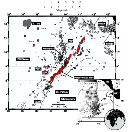
Figure 1 (top): Distribution of earthquakes in Ethiopia. Light grey circles
are earthquakes during 1960–2008 located from regional and global
stations [Ayele and Kulha´nek, 1997] (NEIC). Dark grey circles are
earthquakes during October 2001 to January 2003 located using a dense
local network of seismic stations. Earthquakes recorded by the EAGLE network
deeper than 22 km are coloured magenta. All earthquakes are scaled to
magnitude. Solid black lines show Miocene border faults, and the dashed
lines show the Debre-Zeit (DZVL) and Yerer-Tullu-Wellel (YTVL) Volcanotectonic
Lineaments. The blue star shows Addis Ababa, and the green diamond shows
Debre Zeit. Red filled segments show the volcanically active rift axis
of the MER. White stars are major Palaeogene-Quaternary volcanic centres
on the NW Plateau. Inset shows topography of the region. White triangles
are temporary seismic stations during October 2001 to January 2003. Tectonic
plates are labelled as follows: A, Arabian; D, Danakil; N, Nubian; S,
Somalian. Major rift zones are labelled as follows: RS, Red Sea; GA, Gulf
of Aden; AD, Afar Depression.
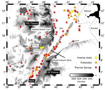
Figure 2 (bottom): Distribution of known thermal springs (red stars),
thermal wells (yellow diamonds), and fumaroles (orange triangles) plotted
on the topography of Ethiopia. Geothermal features are prevalent along
the axis of the MER and on the NW plateau but are completely absent on
the SE plateau. Data provided by G. Demissie of GeoMET Plc.
Full paper (pdf file)