
Cornwell et al, 2010
Imaging detailed crustal structure and magmatic intrusions across the Ethiopian Rift using a dense linear broadband array by D. Cornwell et al, 2010
Non-technical summary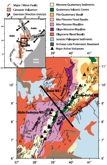
How the continental crust rifts as the tectonic plates move apart is controlled by the nature of the rocks in the rift zone. Recent studies in Ethiopia show that the Cenozoic (65.5 million years ago to the present day) northern Main Ethiopian Rift has developed within ancient Precambrian (1000-542 million years ago) crust (figure 1 right). A 400km long line of 91 seismic stations running southeast across the rift from the Ethiopian plateau to beyond the southern margin was set up to record seismic data from around the world. Seismic data are records of the waves of energy created by global earthquakes. These waves travel through the Earth and are picked up by stations at the surface. The varying times at which they arrive at the stations provides information on the rock layers they have travelled through.
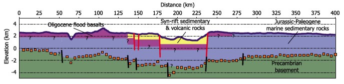
The results of the study are shown in the cross sections in figures 2 and 3. Figure 2 (below) is a sketch cross section through the near surface geology. Figure 3 (bottom of page) shows the variation in the ratio of the speed of the primary (P) and secondary (S) seismic waves through the crust (a ratio that allows us to determine what rocks the crust is made from and if they are solid or molten).
The youngest rocks in the region are Miocene to Recent in age (23 million years ago to the present day). These are the sediments and volcanics found across 110km of the central rift zone that were deposited and erupted during the early stages of rifting. Beneath these and to the northwest of the rift zone are Oligocene (35-23 million years ago) flood basalts (extensive lava flows). The depth of these lavas is uncertain. However, the boundary between them and the underlying Jurassic-Palaeogene sediments can be seen in a gorge about 75km along the profile indicating that here they are less than 800m thick. The Jurassic-Palaeogene (200 - 35 million years ago) sediments are marine in origin, indicating the region was at or below sea level at this time. Beneath these lies the ancient metamorphic rocks of the Precambrian of the upper crust. The boundary between the Jurassic-Palaeogene sediments and the Neoproterozoic rocks varies from 2.8-6km deep. Large faults associated with rifting cut this boundary.
At depth (figure 3), the profile can be divided into four regions on the basis of the thickness and properties of the crust.
Beneath the northwestern rift flank (0-115km along the profile) the crust is between 36-42km thick. The lower and middle crust is mafic (consists of rocks rich in iron and magnesium), whilst the upper crust is felsic (rocks rich in silica, oxygen, aluminium, sodium and potassium). A dense layer 6-18km thick and between 27km and 48km deep is interpreted as being related to repeated magma intrusions. The molten rocks never reached the surface but solidified at this depth. This layer may still contain some partially melted rocks. Rifting is concentrated where this layer is thinnest indicating that the strength of this layer has controlled the location and development of the northern Main Ethiopian Rift in this region.
Under the rift itself the crust is 32-36km thick and can be divided into two regions. The northwestern region has thinner crust and contains partially molten rocks. This is interpreted as a poorly developed magma system. The southeastern region is interpreted as having a well-developed magma system with magma chambers in the upper crust and a plumbing system stretching down into the lower crust.
Beneath the southeastern rift flank is a 35km wide zone, which marks the transition from thinned crust beneath the rift to the thick, unrifted crust of the rift flank.
For the rest of the southeastern rift flank the crust is 37-41km thick and shows no evidence for magmatic intrusions.
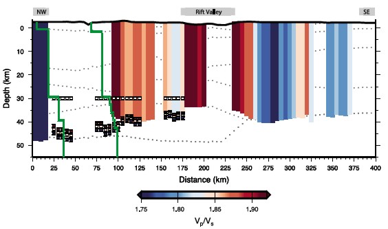
Figure 1 (top) A simplified geological and structural map of the northern main Ethiopian rift with magmatic segments (MS) and border faults (BF). The bold line indicates the location of the cross-riftprofile. The inset shows the tectonic setting of the northern East African rift system with major faults, volcanism, extension rates and directions between plates (adapted from Cornwell et al, 2006 and references there in).
Figure 2 (middle) Sketch diagram of the likely near-surface structure and geological units beneath the cross-rift profile. Bold black and red lines indicate fault zones.
Figure 3 (bottom) Cross-rift profile showing the variation in the ratio of the primary and secondary seismic waves through the crust beneath the rift.
Full paper (pdf file)